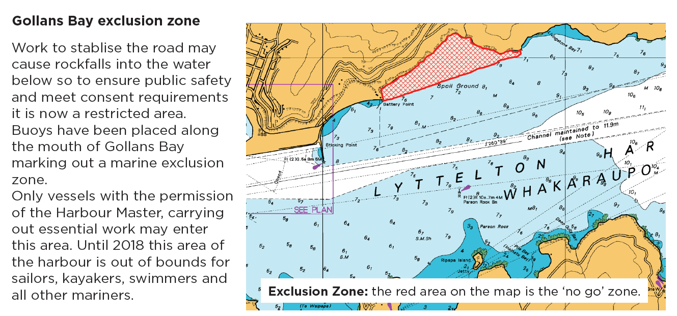
Gollans Bay is a Marine Exclusion Zone while work is carried out on Sumner Rd. Protection from rockfall is the purpose of the exclusion. This update 3 February 2017
_______________________________________________________________________________________________________
Ecan Bylaw was changed in October 2016 and lifejackets are to be worn at all times in small craft, including kayaks.
________________________________________________________________________________________________________
Ecan Navigation Safety Bylaw is being reviewed, May - July 2016
Click here
KASK has submitted on wearing lifejackets
Avon river rules are likley to stay the same
-------------------------------------------------------------
15 November 2012
Always check that the weather forecast on VHF from the Coastguard, is for that day. They are still (after 3 years) not always automatically updating their presentation.
~~~~~~~~~~~
22 June 2011
Latest report is that the Quail island cliffs are probably even more unstable after Monday, 13 June.
~~~~~~~~~~~
Navigation on the Avon (eventually)
The current Ecan Navigation Safety Bylaws document.
Click Here
Also has a diagram.
11.2 Reserved Areas and other provisions for Rivers AVON RIVER/ŌTĀKARO 11.2.1
Maritime Rule Part 22 – Collision Prevention, made under the Maritime Transport Act 1994 does not apply to the Avon River/Ōtākaro between the upstream limits of Kerrs Reach and the boundary with the Avon and Heathcote Rivers Estuary / Ihutai.
Rules 11.2.2 to 11.2.4 apply in its place.
AVON RIVER /ŌTĀKARO NAVIGATION RULES
11.2.2
A traffic lane shall operate in the Avon River / Ōtākaro between the upstream limits of Kerrs Reach and the boundary with the Avon and Heathcote Rivers Estuary / Ihutai. Manoeuvring in this traffic lane shall proceed as follows:
(a) Rowing sweep and sculling craft and large paddled craft [6 man out-rigger, dragon boats and surf boats] travel downstream and upstream on the right side of the river (i.e. they keep the nearest bank on their starboard side or bow side).
(b) Small paddled craft, [kayaks, 2 man out-riggers] travel downstream and upstream on the left side of the river (i.e. port side to bank), facing oncoming large paddle or oared craft.
11.2.3
Overtaking crews must give way.
11.2.4
Crews travelling upstream have the right of way.
~~~~~~~~~~~
26 April 2011
Reported in The Press 26 April,
Click Here
That a week ago the Health Department stated that Lyttelton Harbour is clear of sewerage and safe for recreational use .
Also reported that the Rapaki Maoris are placing a rahui on the harbour for recreational use, 2 months after the event that might have caused sewerage to be present in the waters of the harbour !!!
The rahui is to be imposed for 3 months, maybe.
See the discussion page for a fuller analysis.
Sandy
~~~~~~~~~~~
27 March 2011
There's water based activity starting again from Naval Point and the Public slipway. The school kids and trailer sailer yachting is back in full swing, I've been out a couple of times in an OC6 (last Thursday and Sat) and there are stand up boardies and kayaks out also. We launch at Naval point and head out across the channel to the other side towards Ripapa Island. Haven't heard any more re Cass Bay so would tend to stay away.
If you are getting scratchy for salt water the Public Slipway or Naval Point might be a launching option and head across and down the other side of the harbour.
(from P.S.)
~~~~~~~~~~~
8 March 2011
Banks Peninsula Navigation Warning
Quail Island
Paddlers visiting Quail Island in Lyttelton Harbour need to be cautious of further rock falls following the 22 Feb 2011 earthquake.
Following a reconnaissance this morning by J K-A, 8 March -
There have been many minor rock falls around the island, several in unexpected places, but the main concerns are unstable rocks above the caves on the north eastern side.
The big cave has had a rock fall to the left, as looked at from the sea, and this has left loose rock sitting on ledges. The smaller caves have had falls from directly above their entrances, but to the right of the smallest cave a large area of cliff looks very unstable. There are vertical cracks running right to the top and it looks ready to fall.
The large cliffs on the eastern side of the island have all had rocks fall away, burying the penguin nests, and the bay to the right of the caves, closest to the northern tip, is full of very large rocks that have completely covered the stony beach.
Around the north western side there has been some rockfall in the basalt quarries, but nothing looks unstable.
The barracks and toilets are undamaged, but a small crack runs between the barracks and the sea wall, indicating lateral spread.
Given the likelihood of aftershocks, paddlers are advised to stay away from the cliffs, and particularly around the caves.
(J K-A)
~~~~~~~~~~
Cass Bay
There have been reports that raw sewerage is being pumped out from there - needs confirmation but should be taken as happening unless otherwise reported.
~~~~~~~~~~
Port Levy
Falls of rock around Pukeiti Point and to the seaward side of Brownes Island, the latter cliff looking most unstable from the September quake. A large amount of rock was seen to fall off Adderley Head during the 6.3 quake.
(Sandy)
 Admin Login